Environmental Partners is currently assisting several municipalities with the development of Nutrient Source Identification Reports for their stormwater programs. As part of the NPDES Phase II Stormwater MS4 Permit; Massachusetts communities that do not have a Total Maximum Daily Load (TMDL) associated with their municipal waterways (such as the Charles River Watershed TMDL) but have known water quality impairments of Nitrogen and/or Phosphorus are tasked with the process of developing a Nutrient Source Identification Report.
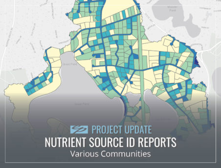
By looking at a combination of factors including Soil Types, Hydrological Data, Contours, and Land Use / Landcover information, we have been able to identify the highest nutrient loading areas of the contributing areas to the impaired waterways. By using the nutrient loading data and a series of localized maps, we can provide the Town with recommended areas and parcels for potential stormwater BMP installations (either by new construction or stormwater retrofits). Based on the contributing land area of the Town’s impaired waterways and limited municipal land to work with; some of the recommendations fall within the municipal road ROW – and examples could include Tree Box Filters or subsurface treatment structures.
We look forward to continuing the conversation on these projects as the MS4 communities look to install treatment options to not only comply with their MS4 Permit requirements, but to greatly reduce nutrient loading to our local waterways. This in turn will improve the stormwater water quality and overall natural resources of our region.